Day 76: June 13th: Alright, Who's in Charge Here?
Let me start off by saying: The 8 mile section leading out of Pearisburg was the most repulsive part of the trail I've experienced so far. Thank god PMac and I decided not to camp on the edge of town, because I felt grimy just passing through. Surprisingly, the two of us actually left town around 7am - but it was a really shitty morning. First off, the trail was not maintained at all - forcing us to walk through vines and spider webs and overgrown brush. Those who did choose to camp on the edge of town decided to sleep in the cemetery - at least there was grass there, I suppose.
After crossing paths with a hungry trail kitty, we crossed over a busy bridge that lead us over by some factory. GROSS! Then, we crossed a little stream that had signs posted warning us to not drink the water! Granted, there have been other water sources that seemed unfit to drink, but none that specifically stated that they were contaminated. PMac and I stopped briefly along the way to elevate our injuries, but I wanted to put Pearisburg behind me, both literally and figuratively. I listened to Iron & Wine all morning, in an attempt to brighten my foul mood.


Yuck!

Sorry, but I tend to like my trail not contained between two chain-link fences.

Road-walking - la la la.

This just felt wrong.
Stop poisoning our earth!
Side note: I absolutely LOVE my AWOL guidebook - it's definitely the best resource out there (though, there are new GPS apps that tell you exactly where you're located, have pictures of the shelters, and allow you to make comments for other hikers to see, amongst other features - Rain-Man has this, it's really cool), but I must say, the 2014 version does NOT accurately depict this section. PMac and I were extremely confused as to what was going on/how many miles we had left/etc until Rain-Man came along and we compared the 2014 and 2015 versions. Granted, the trail gets re-routed every year, but this was the most inaccurate information I've had to deal with yet.

I felt the need to tell everyone on the trail how I felt...
We arrived at Rice Field Shelter to find the most awkward privy I've seen yet - no walls and located about 5 feet off the trail. You guys know how much I love those!


Adventure pooping!
Luckily, this is where the trail stopped being so dirty (ha - we're in the woods, we're always dirty). The shelter looked out into a gorgeous field, and we caught a glimpse of West Virginia. The overlook was spectacular, but the day was hot, so PMac and I continued along through the field and weeds, noting that this was a perfect habitat for ticks.


Fields are the best! Finally, the first bit of beauty in quite a while.

Rain-man decided to take a quick little cat-nap by the shelter.

Fields and clouds. Clouds and fields.

A little taste of West Virginia. See you again in a few hundred miles!

Overlooking civilization!
Perfectly puffy clouds.
An hour or so down the trail, Rain-Man caught up to us and delivered some upsetting news - Lady Unicorn had decided to get off the trail the following morning. I knew she hadn't been happy, none of us had been - but I didn't realize that she was even considering leaving the trail. We waited around for a bit in hopes she would catch up, but ultimately decided to talk with her that evening and try to understand her reasoning.


Gentle slopes are the best slopes!
Thankful for the scorching sun that fuels our earth and gIves me sun-kissed skin.
The rest of the day was awesomely flat. Wooo! We arrived at Pine Swamp Branch Shelter around 7pm and waited for Lady Unicorn to arrive. I didn't want to bombard her with questions, but I definitely wanted to hear her story. Despite wanting to stop for the night, we pressed on another 2 miles so that we could camp at "The Captains".

Shitty fires, shitty pictures of shelters.
On the way, Lady Unicorn confessed to us that she came onto the trail with the intention to stop when she felt it was time to stop. She hadnt felt the desire to hike in quite a while and decided that her time would be better spent back home with her father. She then informed us that she already had a ride that would pick her up in the morning at The Captains. I respected her choice to leave, but I was still bummed about it, as I really enjoyed her company and we walked at a similar daily pace.

Thank you Captain - I never got a chance to express my gratitude!
In order to get to The Captains, you are required to take a mini zipline across the river. It was a bit intimidating, but it turned out to be fun! Though I never actually met the Captain, I am thankful for his hospitality and the variety of free sodas he provided (seriously, there were a ton of odd flavors - I chose peach)!

The best way to cross a river!

Hooks for your pack, and a seat for your butt!
The Captains yard was FULL of those tiny lime green jumping bugs. They don't bite, but they tried to get in my tent with me. No way - I sleep in a tent built for one.

I haven't mustered up the courage to cowboy camp yet! Bugs and rain always make me paranoid.

Hanging around the fire-pit!
Shelter: "The Captains"
Miles today: 20.5
Miles from Springer: 651.8
Miles to Katahdin: 1533.5
My reluctance to leave my group in Pearisburg and go off on my own made me realize I was getting way too comfortable - it was time to step out of my comfort zone and hike by myself. Though it is (exponentially) more fun to hike with friends, I don't always get what I need - solitude, the opportunity to reflect on my life off the trail, etc. Hiking alone (for a decent stretch of time) forces you to rely solely on yourself - it is an excellent method of personal and spiritual growth.
And so I left. I said my goodbyes to Lady Unicorn, zipped across the river and left. I spent the majority of the day leap-frogging with Rhino, listening to music and enjoying my time alone.

Pretty average day: crossed some roads, read some log-books at shelters, saw some views, photographed some privies.


Rhino and I stopped by Wind Rock for a minute to enjoy the overlook, but thunder was threatening and we decided to haul ass out of there.


I can happily say that we both made it to War Spur Shelter just before the rain hit. Sam-I-Am and Iris were already set up for the night, but Rhino and I stayed just long enough to wait out the rain. Again, it would've been nice to stop at this shelter, but I was ready to put in some miles.
The section up to Kelly Knob was a bit brutal - it was basically straight up for 2.5 miles. But even though it seemed never-ending, I was grateful to notice that I finally had gotten my trail legs. I knew I had been getting stronger each day, but I was legitimately impressed with my stamina and endurance.
Kelly Knob is supposed to be a really beautiful spot, but I arrived at a time when the air was heavy with haze. It felt as if the view was kinda blurry... It was here that I met a few weekenders - I was extremely jealous of their 3-mile day. One of them mentioned how he wanted to do a thru-hike, but didn't have anyone to join him - I responded by telling him to do it anyway! Seriously, the initial fear of doing things alone should never be an excuse. I've had fellow thru-hikers come up to me and express that they were envious of my solo thru-hike. Honestly, I can't blame them - it's awesome!

Rhino and I arrived at Laurel Creek Shelter and set up for the night. It was getting late, so we assumed we would be alone (things have started to thin out), but soon enough Buns and Waldo made an appearance - and eventually, so did PMac. We all shared the shelter - Yay for slumber parties!

Vain, unnecessary selfies make the world go round.
Pretty average day: crossed some roads, read some log-books at shelters, saw some views, photographed some privies.

Stony Creek Bridge.
Quality.

VA 635.

The privy at Bailey Gap Shelter!
Rhino and I stopped by Wind Rock for a minute to enjoy the overlook, but thunder was threatening and we decided to haul ass out of there.

Yes. Let us all take responsibility, and respect our planet.

Another sweet blaze!

An outdated binocular-type machine?

Storms comin!

Though I find it tacky to write on wooden signposts, these modifications are usually helpful.
I can happily say that we both made it to War Spur Shelter just before the rain hit. Sam-I-Am and Iris were already set up for the night, but Rhino and I stayed just long enough to wait out the rain. Again, it would've been nice to stop at this shelter, but I was ready to put in some miles.
The section up to Kelly Knob was a bit brutal - it was basically straight up for 2.5 miles. But even though it seemed never-ending, I was grateful to notice that I finally had gotten my trail legs. I knew I had been getting stronger each day, but I was legitimately impressed with my stamina and endurance.
Kelly Knob is supposed to be a really beautiful spot, but I arrived at a time when the air was heavy with haze. It felt as if the view was kinda blurry... It was here that I met a few weekenders - I was extremely jealous of their 3-mile day. One of them mentioned how he wanted to do a thru-hike, but didn't have anyone to join him - I responded by telling him to do it anyway! Seriously, the initial fear of doing things alone should never be an excuse. I've had fellow thru-hikers come up to me and express that they were envious of my solo thru-hike. Honestly, I can't blame them - it's awesome!

If you climb down into Kelly Knob, there is a cave to explore!
Rhino and I arrived at Laurel Creek Shelter and set up for the night. It was getting late, so we assumed we would be alone (things have started to thin out), but soon enough Buns and Waldo made an appearance - and eventually, so did PMac. We all shared the shelter - Yay for slumber parties!

Decent shelter - definitely home to a mouse though!

I am thankful for beautiful glitter glue, showing us the way.
(Honestly, the privy was really difficult to find. Lots of mini-trails that lead nowhere.)

I awoke the next morning to Buns informing me of my snoring - a shelter-sleepers worst nightmare!
Shelter: Laurel Creek Shelter
Miles today: 17.3
Miles from Springer: 669.1
Miles to Katahdin: 1516.2
I started the day by soaking my feet in the creek - ice is hard to come by in the middle of nowhere, so I take what I can get. PMac and I hiked together all morning - this section was directly in the sun and required us to walk on little bridges through a bog (which I thought was really cool - anything different is interesting).


Woke up, peed near this tree. Looked up - frog! 3 inches from my face!

PMac amongst all our hiking gear.

Trekking poles
(with an appearance by Buns' Cascadia trail-runners)

Open fields = no shade.
No shade = sweat. Lots of it. Soaking into your pack straps.
We came upon some trail-magic, so we stopped and hung out with Buns and Waldo for a few. Afterwards, we spent some time at Keffer Oak, the largest Oak tree on the southern AT. Buns made an attempt to climb it, but falling from that tree would instantly end a thru-hike, so he stopped at a reasonable point.

You go, Keffer Oak!

Buns beginning his brave climb.

Tree-climbing is a spectator sport.

Alright, alright, that is high enough.
I had wanted to stop by Sarver Hollow Shelter, but it was .4 off down a steep hill and my group was not having it. Rumor has it that the shelter is a really awesome one. I guess I'll never know.
As I continued along, I ran into a SOBO that I definitely saw walking SOBO the past day or so. I asked him what his deal was and found out that he is in a group (headed by Warren Doyle, a man who has hiked the trail like 17 times) that is slack-packing the entire AT. They technically hike south everyday, but then their van meets them and takes them north to do another SOBO section. Further investigation lead me to discover that these participants have been preparing for 2 and a half years. Personally, I wouldn't want to miss out on all the trail culture that happens at shelters. And not to mention the fact that they can't stop when they want or take any zero days!


Rolled hay-bales are adorable and funny.

Mysterious stone structures in the forest.

Perfect sky!

Love stumbling upon random signposts!
Shelter: Camping at "Craig Creek"
Miles today: 13.8
Miles from Springer: 682.9
Miles to Katahdin: 1502.4
I got up around 530 and was out by 6. I was waiting on PMac, but even after doing my makeup (I've been neglecting it lately) and killing some time, she still wasn't ready and I was antsy. That morning hike was fantastic - one of my favorites. The temperature was perfect, the lighting was pleasing and the wind gave me a luxurious breeze the entire time.

Homes of Buns and Rhino.
I summited Brush Mountain and took my pack off while I checked out Audie Murphy Monument. There was a sign for an overlook, so I ventured a little further and felt completely in my own little world - hence my absolute surprise when I turned around and saw someone. He introduced himself as Yogi, we talked for a bit, and he was on his way.

It's amazing how quickly I am now able to walk 3.7 and 7.5 miles. So impressed with my trail-legs!

One of the nicer monuments along the trail.

Thank you to all our Veterans.

More lives lost :(
This is where Yogi scared the crap out of me.
I stopped to soak my feet/knees in Trout Creek, where Buns and PMac caught up. I knew I wanted to pit-stop at Pickle Branch Shelter, which was .3 off, so I didn't stick around for long. The shelter itself wasn't great, but the surrounding area would have been perfect for a giant hiker party. I got lost trying to find my way out, it was slightly alarming...

Only 4 more miles to Dragon Tooth!

The privy belonging to this shelter was weird...

Sometimes, my life consists of walking through fields of flowers. No complaints.

How helpful! Thank you, signpost.
Though the guide-book made this section look easy, the trail was located on these significantly slanted rocks, resulting in some slow-going in the sun. But I soon came upon the detour to Dragons Tooth, where I found Buns. We were both pretty annoyed, especially because Warren Doyle passed us SOBO and (quite joyfully, it seemed) informed us that the .7 after Dragons Tooth was the most difficult section of the entire AT. Fucking Warren Doyle.


We live for these views!
Puts Long Island to shame.

A shot from behind Dragons Tooth.
Buns likes climbing things apparently. So he climbed to the top of Dragons Tooth. Considering I was wearing a dress, and I'm pretty terrified of heights, I did not join him.

You do your thing, I'll do mine.
Which is not climbing things.

Victory!
So we pressed on - and saw that Warren Doyle was right in saying it was a difficult section, but it wasn't nearly as bad as I imagined it would be (maybe he set me up for a pleasant surprise). But I was definitely glad for the day to be done.

I climbed down this.
With 30 lbs on my back.

Lost Spectacles Gap!
Buns waited for me at the road, where we then walked to Four Pines Hostel to check it out. I wanted to shower, rehydrate and continue on to at least the next shelter, but we were offered an opportunity to slackpack. We were a bit concerned that it would mess up our plan to continue hiking with PMac, but we couldn't turn it down. So we got in the van, drove 6 miles north and SOBO'd it back to Four Pines. When we arrived, we were informed that PMac was currently slackpacking - perfect!

We hit the 700 mile marker!
This one was adorable :D
Four Pines is a hostel I would definitely recommend staying at - it's basically just a huge garage with cots and couches and all the basic amenities a hiker could ask for - I loved the casual atmosphere. Baltimore Jack had been hanging around for a few days - his company is always pleasant and he doles out advice in regards to future sections of the trail. I heard the previous night was a huge party, and was grateful that the evening was very subdued and quiet. Yay sleep!

PMac all cozy!

Baltimore Jack telling stories about rattlesnakes.

Eclectic... and dusty.

Dragon Wagon.
It slackpacked us!
Shelter: Four Pines Hostel
Miles today: 21.3
Miles from Springer: 704.2
Miles to Katahdin: 1481.1
So for a few bucks, Four Pines dropped us back off at the road-crossing and shuttled our packs to the Howard Johnson in Daleville, about 20 miles north. Slack-packing is always refreshing - PMac and I couldn't fit in the first shuttle, so we were a bit behind the group.


Beginning the days journey...
Things were definitely slow-going due to my knee. Even without a pack, my pace was beginning to decrease. I needed to stop at the Johns Spring Shelter, a mile in, in order to readjust my brace and take some pain-meds.
But soon enough, we arrived at McAfee Knob - the most photographed landmark on the entire AT - and spirits were lifted. We took some time to eat, socialize, and sit upon the Knob.


If one doesn't get his photo taken atop McAfee Knob, did he even thru-hike?
Eventually it was time to move on, I went ahead of PMac and began listening to the soundtrack of Chicago on repeat. It began to rain a bit, which I found pleasant due to the bugs and high temperatures. I passed Space Cadet and Yogi by Tinker Cliffs - I would have liked to stay, but it was a long 20-mile day and I didn't want to get caught in the rain for long.


Shout-out to the brave men and women who help guide us on our thru-hiking journey.
I tried to take a break at Lamberts Meadow Shelter, but the bugs were so ridiculously ridiculous that I couldn't stop. Seriously, "no-see-ums" are tiny, their bites are painful, and they can bring even the toughest hikers to the brink of insanity.
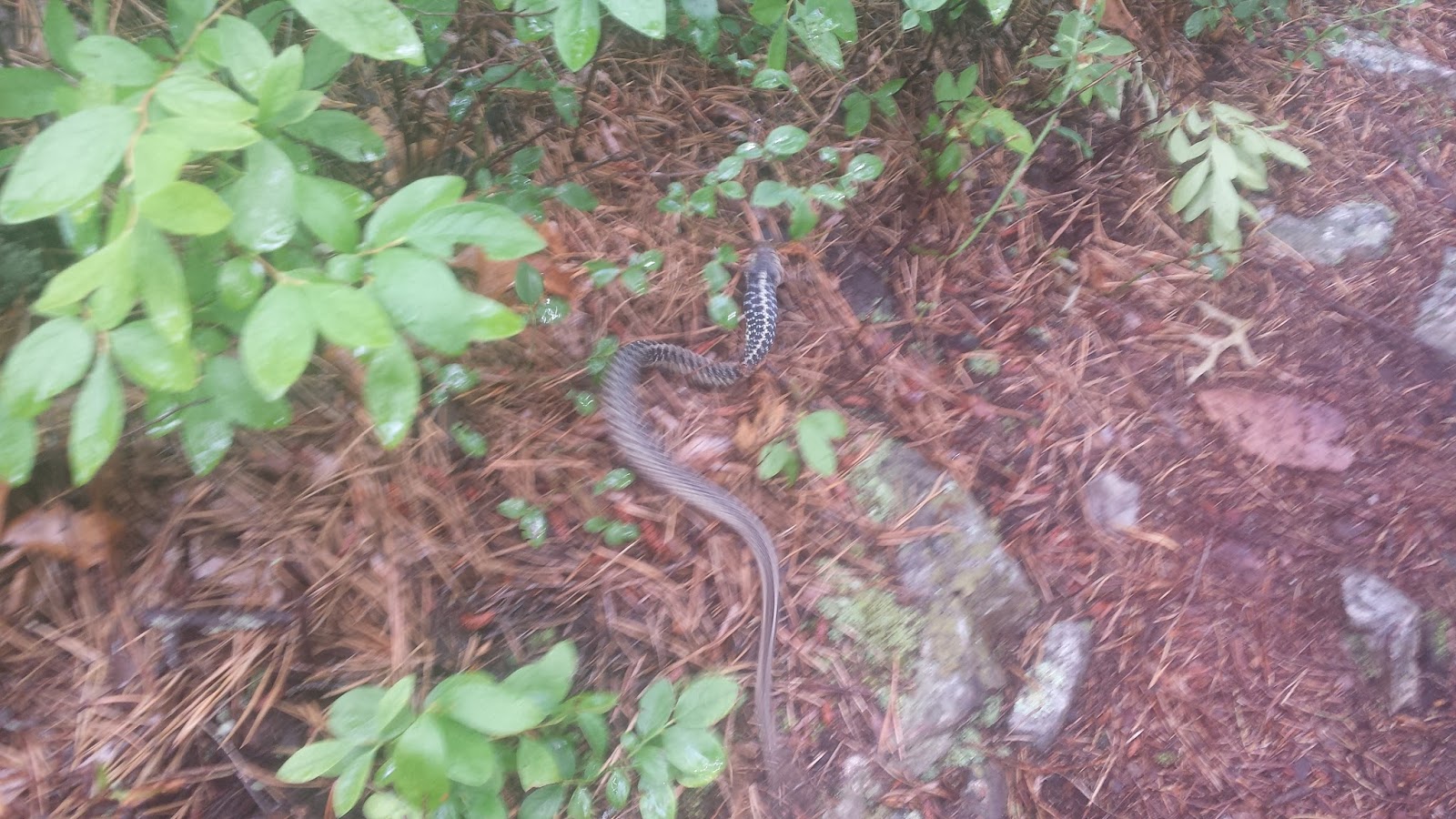
You can't tell from this photo: but this snake is eating a frog.
Again, it began to rain again.... and then it began to rain harder. The following dialogue is pretty much the exact conversation I had with myself: "Wow, it's really raining, I wish I had my rain-gear. Let me stash my mp3 player in my day-pack... Oh god its pouring, my bag is soaking wet, I didn't put my electronics in a zioloc! ...I'm basically taking a shower in my clothes right now. Might as well look up at the sky and wash my makeup off because it's not surviving this torrential downpour. ....I can't possible get more wet than I am right now. WHY THE FUCK ARE BUGS STILL BITING ME WHILE IT'S POURING?! ...At least everyone else is suffering as well, that's kind of comforting. ...The trail is legitimately a river right now. I'm cold. There is literally nowhere to take cover, I have no choice but to continue walking... (45 minutes later...) Oh look! It's slowing up! Wait, all the other bugs are coming out of hiding now, great. I'm soaked, and I still have 9 miles left to hike. UGH. ...I chose this life."
Eventually I found Space Cadet and Yogi again - theu had been hiding under a giant rock (lucky). I took this opportunity to sit down for a bit and dry off. PMac catches up - and it begins to pour once more. We huddled and hid under the rock as best we could, (Yogi let me borrow his rain jacket because I was shivering and all my extra clothes were drenched), while we listened to the lightning and thunder directly overhead. Eventually though, we had no choice but to make a run for it.

And so we finally arrived at the Howard Johnson! Grabbed our packs, PMAC discovered she forgot her wallet at Four Pines, and checked into our rooms. PMac wanted a room to herself, so I shared with Buns (Finally, my own bed! A queen-sized bed I don't have to share with anyone but myself!). I walked into the room and immediately knew I wanted to zero the following day. The hotel was just too nice. A hotel my parents would take us to, not like these questionably-clean motels and hostels I've been getting used to...
That night was Gourmet Greg's birthday - and his best-trail-friends threw a party for the occasion. I stopped by because it would have been slightly socially-unacceptable not to, but I quickly retreated to my room once some random southern hicks decided to join in. I spent the night under cotton sheets, watching TV and eating all the snacks from my mail-drop. Yes.

Slightly foggy, but still good!
And so we finally arrived at the Howard Johnson! Grabbed our packs, PMAC discovered she forgot her wallet at Four Pines, and checked into our rooms. PMac wanted a room to herself, so I shared with Buns (Finally, my own bed! A queen-sized bed I don't have to share with anyone but myself!). I walked into the room and immediately knew I wanted to zero the following day. The hotel was just too nice. A hotel my parents would take us to, not like these questionably-clean motels and hostels I've been getting used to...
That night was Gourmet Greg's birthday - and his best-trail-friends threw a party for the occasion. I stopped by because it would have been slightly socially-unacceptable not to, but I quickly retreated to my room once some random southern hicks decided to join in. I spent the night under cotton sheets, watching TV and eating all the snacks from my mail-drop. Yes.
Shelter: Howard Johnson in Daleville, VA
Miles today: 19.8
Miles from Springer: 724.0
Miles to Katahdin: 1461.3
So basically, I woke up, ate some continental breakfast, chatted with some hikers, walked to the store to buy epsom salts, got a hitch back to my hotel (.25 miles, at most) with a lady who makes dehydrated hiker food and saw me walking, and laid in bed. Seriously, I spent the entire rest of my day in bed. And it was the best day ever. Usually, hikers use zero days to run errands and never get a chance to relax. But I purposely and deliberately set aside this day for absolutely nothing.


Visited the local outfitter.
They couldn't fix my water filter :(
Buns left around noon - he went home for a few days to attend a wedding - which left me with the room to myself (for a little bit, at least). Wrangler and PMac hung around my place due to the pouring rain - but while Wrangler eventually made it back on the trail, PMac wasn't so motivated.


Found: outside all hiker hotel rooms everywhere.
At this point, Octopus was only a few hours behind and would be catching up that evening. We agreed to share a room, but I began to get worried when he hadn't shown up by 10pm. He was slackpacking with a girl named Slow-Mo, and hadn't brought his head-lamp. When they finally arrived, they told us how they got caught up at McAfee Knob due to a wedding proposal! I approve of this proposal (unlike the one at Trail Days).
Sleep.
Shelter: Howard Johnson in Daleville, VA
Miles today: 0.0
Miles from Springer: 724.0
Miles to Katahdin: 1461.3
No comments:
Post a Comment